OnX Hunt App Review
This is a game changer not only for public land and private land hunters alike. The OnX Hunt app has basically everything you need to help you map out your private property or a piece of public land, along with coming up with a pattern on what the deer do. The first cool thing about this app is you can purchase a state. Then, after you buy the app it will show you every piece of public land in the state that you purchased, along with trails, state parks, and a lot more.
Also, if you go under the map tools you can add a waypoint. It gives you many options to pick what you want the waypoint to be. For example, they have stands, deer tracks, a trail camera, a rub, parking, public land access points and a lot more. This helps you when you are trying to find a game camera on some public land that you walked a good two miles to put up. It allows you to click on the waypoint you created and click “Go to Waypoint.” Then, it will proceed to show you the fastest way to your camera.
One example where I got caught up in a problem happened when I got turned around in Wisconsin. I created a waypoint at the area I parked, and it helped me find my way in the dark. Another cool feature that I use a lot is a feature called “Tracker.” Essentially, it shows a big red line that you walked. So, I use this when I'm finding the quickest and quietest way to my stand. I mark it down and it helps you follow that track back to the stand which helps you sneak into your stand. You can also turn it on when you are tracking your deer to see where you've been around that parcel of land to help narrow the spots you haven't looked. That is a pretty cool feature that I have found helpful.
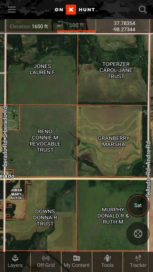
This app also helps you find out names of owners of parcels adjacent to you which can help you figure out the name and give them a call or if you just need to check to see if you're on public land or not. OnX also has a sweet feature when you click on parcel of land, it will show you how many acres it is, any regulations on what you can use to hunt in this area, if it’s a CWD area, and what unit/zone you are in.
Overall, if you are a serious public land hunter, it's almost a necessity. It will be the best purchase you will have made when it comes to upping your hunting game. Without this app, I wouldn't know half of the public land parcels I know now, and I can be confident in determining whether it's public land or not. This app also gives you the cast on the weather for the day, as well as, the week. It tells you the temperature, wind mileage and direction, precipitation, barometric level, sunrise and sunset times for the day.
RATED ON A 10 SCALE
Price: 7
The Price to purchase mapping for a state is $29.99 for the year. There are also a lot of promotions through some of the top hunters in the industry that offer a 20% discount code if you use their code. So that would bring it down to $23 for the year. They also offer the elite yearly membership which gives you access to all 50 states. This is what I do because I'm hunting three different states this year.
User Friendly: 7
This app will take some time and messing around with to perfect it and figure out every way possible to utilize the features, but once you get all that down, the app is very user friendly and easy to use.
Overall Rating: 10
This app has changed the way I hunt because it allows me to find hunting land to scout, and it allows me to add waypoints to help me better utilize what I've seen on this land and pinpoint that big buck.
-Dillon Lee, Fall Obsession Field Staff